Unified Text Guidance Viewer
Single-Station Products
| City | Client | ZFP/PFM | MOS | NBM | FCT |
|---|---|---|---|---|---|
| Minnesota | |||||
| Albert Lea | AEL | Freeborn | AEL | AEL | AEL |
| Minneapolis | MSP | Hennepin | MSP | MSP | MSP |
| Duluth | – | St. Louis | DLH | DLH | DLH |
| Iowa | |||||
| Oelwein | Northeast IA Amish | Buchanan | OLZ | OLZ | OLZ |
| Iowa City | East Central IA Amish | Johnson | IOW | IOW | IOW |
| Centerville | South Central IA Amish | Appanoose | TVK | TVK | TVK |
| Missouri | |||||
| Kirksville | Northeast MO Amish | Macon | IRK | IRK | IRK |
| Mount Vernon | Southwest MO Amish | Lawrence | SGF | SGF | SGF |
| Illinois | |||||
| Carbondale | South Central IL Amish | Jackson | MDH | MDH | MDH |
| Champaign | East Central IL Amish | Douglas | CMI | CMI | CMI |
| Northern Wisconsin | |||||
| Hayward | Cranberry R3 | Sawyer | HYR | HYR | HYR |
| Apostle Islands Nearshore | – | LSZ150 | DISW3 | DISW3 | DISW3 |
| Ashland | – | Ashland | ASX | ASX | ASX |
| Tomahawk | WJJQ | Lincoln | TKV | TKV | TKV |
| Rhinelander | Cranberry R4 | Oneida | RHI | RHI | RHI |
| Central Wisconsin | |||||
| Eau Claire | – | Eau Claire | EAU | EAU | EAU |
| Medford | MDZ (Vantage) | Taylor | MDZ | MDZ | MDZ |
| Marshfield | Central WI Amish | Clark | MFI | MFI | MFI |
| Wausau | WCLQ/Granite Peak | Marathon | AUW | AUW | AUW |
| Black River Falls | Cranberry R1 | Jackson | BCK | BCK | BCK |
| Wisconsin Rapids | Cranberry R2 | Wood | ISW | ISW | ISW |
| Northeast Wisconsin | |||||
| Green Bay | – | Brown | GRB | GRB | GRB |
| Door County Nearshore | – | LMZ541 | 2P2 | 2P2 | 2P2 |
| Fond du Lac | Eastern WI Amish | Green Lake | FLD | FLD | FLD |
| Southwest Wisconsin | |||||
| La Crosse | – | La Crosse | LSE | LSE | LSE |
| Viroqua | West Central WI Amish | Vernon | Y51 | Y51 | Y51 |
| Platteville | Southwest WI Amish | Grant | PVB | PVB | PVB |
| Richland Center | WRCO | Richland | LNR | LNR | LNR |
| Baraboo / Wis. Dells | – | Sauk | DLL | DLL | DLL |
| Middleton | – | Dane | C29 | C29 | C29 |
| Madison | – | Dane | MSN | MSN | MSN |
| Southeast Wisconsin | |||||
| Watertown | – | Jefferson | RYV | RYV | RYV |
| Lake Geneva / Burlington | Lake Geneva Cruise Line | Walworth Lake Geneva | BUU | BUU | BUU |
| Milwaukee | MKE / MMSD / LE | Milwaukee | MKE | MKE | MKE |
| Milwaukee Nearshore | Lake Express | LMZ645 | 45013 | 45013 | 45013 |
| Upper Michigan | |||||
| Copper Harbor | Mt. Bohemia (8NE) | Keweenaw | P59 | P59 | P59 |
| Calumet | Mt. Bohemia (27SW) | Houghton | CMX | CMX | CMX |
| Northern Lower Michigan | |||||
| Harbor Springs | Nub’s Nob | Emmet | MGN | MGN | MGN |
| Gaylord | Northern Lower MI Amish | Otsego | GLR | GLR | GLR |
| Cadillac | Caberfae Peaks | Wexford | CAD | CAD | CAD |
| Big Rapids | West Central Lower MI Amish | Mecosta | RQB | RQB | RQB |
| Southern Lower Michigan | |||||
| Southern Lake Michigan | Lake Express | LMZ673/872 | 45007 | 45007 | 45007 |
| Muskegon Nearshore | Lake Express | LMZ846 | 45161 | 45161 | 45161 |
| Muskegon | Lake Express | Muskegon | MKG | MKG | MKG |
| Three Rivers | Swiss Valley, Southern Lower MI Amish | Cass | HAI | HAI | HAI |
| Indiana | |||||
| Washington | Southwest IN Amish | Daviess | DCY | DCY | DCY |
| Richmond | East Central IN Amish | Wayne | RID | RID | RID |
| Fort Wayne | Northeast IN Amish | Allen | FWA | FWA | FWA |
| Warsaw | North Central IN Amish | Kosciusko | ASW | ASW | ASW |
| Kokomo | Central IN Amish | Howard | OKK | OKK | OKK |
| Kentucky | |||||
| Flemingsburg | Northeast KY Amish | Fleming | FGX | FGX | FGX |
| Crittenden | North Central KY Amish | Owen | CRIK2 | CRIK2 | CRIK2 |
| Glasgow | South Central KY Amish | Hart | GLW | GLW | GLW |
| Mayfield | Western KY Amish | Graves | M25 | M25 | M25 |
| Ohio | |||||
| Bellefontaine | West Central OH Amish | Logan | EDJ | EDJ | EDJ |
| Wilmington | Southwest OH Amish | Brown | ILN | ILN | ILN |
| Mansfield | Central OH Amish | Richland | MFD | MFD | MFD |
| Wooster | North Central OH Amish | Holmes | BJJ | BJJ | BJJ |
| New Philadelphia | East Central OH Amish | Tuscarawas | PHD | PHD | PHD |
| Cleveland Nearshore | – | LEZ146 | 45169 | 45169 | 45169 |
| Youngstown | Northeast OH Amish | Trumbull | YNG | YNG | YNG |
| Jackson | Southeast OH Amish | Gallia | I43 | I43 | I43 |
| Pennsylvania | |||||
| State College | Central PA Amish | Centre (S) | UNV | UNV | UNV |
| Hagerstown (MD) | South Central PA Amish | Franklin | HGR | HGR | HGR |
| Somerset | Southwest PA Amish | Somerset | 2G9 | 2G9 | 2G9 |
| Lancaster | Southeast PA Amish | Lancaster | LNS | LNS | LNS |
| Maryland | |||||
| Westminster | Northern MD Amish | Carroll | DMW | DMW | DMW |
| New York | |||||
| Penn Yan | West Central NY Amish | Yates | PEO | PEO | PEO |
| Johnstown | East Central NY Amish | Montgomery | NY0 | NY0 | NY0 |
| Virginia | |||||
| Bridgewater | Northwest VA Amish | Rockingham | VBW | VBW | VBW |
| North Carolina | |||||
| Wilkesboro | Northwest NC Amish | Yadkin | UKF | UKF | UKF |
| Season | Special Forecast Products |
| Warm | WI Cranberry: Regional Vine-Level Low Temp Extended Guidance |
| Cold | Ski: Region Averaged NBM Guidance Mt. Bohemia |
| WxChallenge | WxChallenge Parsed Guidance Data WxChallenge Guidance Verification |
Observations + Analysis
Situational Awareness Dashboard
2 Mills Timber (Lagrange, IN; IN-05) Regional Precipitation Report
Ammon Miller (New Providence, PA; PA-40) Regional Precipitation Report
Surface Plots
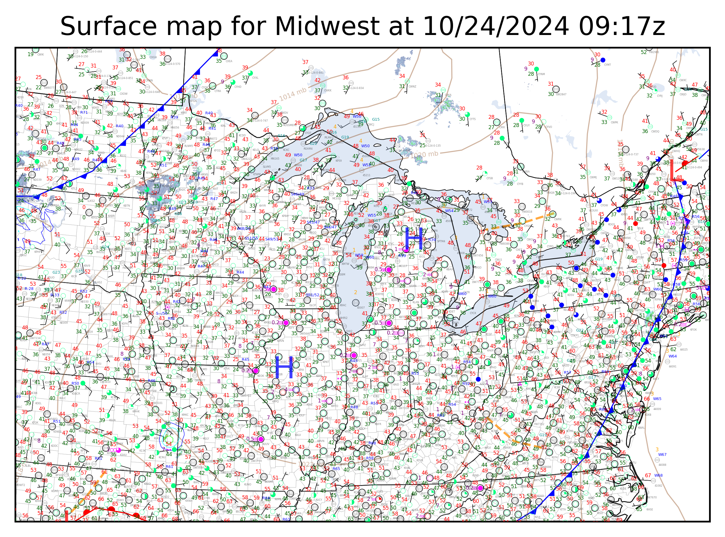
Regional [40 km]: Midwest
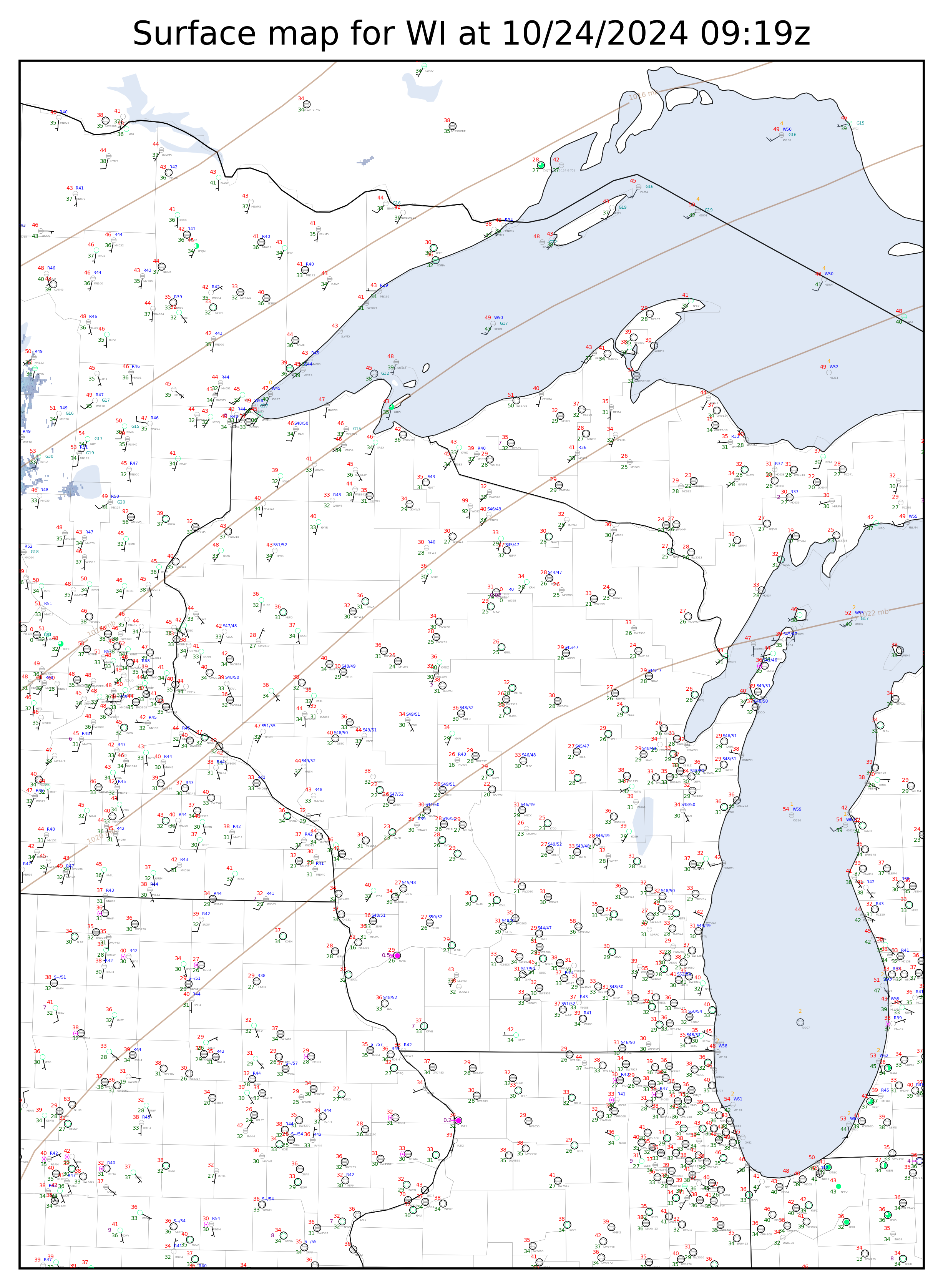
High-Resolution [8 km]: Wisconsin
Data notes:
All sectors are updated every 15 minutes.
Includes data from the ASOS, NDBC, Wisconet, RWIS/RAWS/DCP, ARPS/CWOP, and SSEC networks.
Stations reporting in METAR format use standard flight category color coding for the station symbol.
Blue numbers indicate surface temperatures. W for water, R for road, and S for soil (2 in./4 in.), when available.
Non-ASOS stations with surface moisture sensors use a “(.)” symbol to indicate observed moisture of any kind.
Orange numbers indicate surface wave heights, in feet.
All temperatures are in F, all winds are in knots, and all visibilities are in miles.
Troubleshooting
Most recent UTGV product generation log
Most recent map generation log
Most recent NBM automation log
All products update at :10 and :40 the hour.